THE BEST STREET IN CROYDON
Around 1995 I was reading a 19th century magazine in Croydon's excellent central library when I noticed a reader's letter from a boy who gave his address as Wellesley Road, Croydon. That surprised me. Wellesley Road was a just a soulless concrete canyon full of offices. Like most people who live in Croydon I was an outsider with no connections to the place. I had no interest in the history of the town, but for some reason the thought that the hideous Wellesley Road I knew could once have been full of private houses and families intrigued me. I asked an acquaintance about this and she said Wellesley Road had been the best street in the town. It was known for its trees, greens and beautiful houses. She added that the Whitgift Shopping Centre had until the 1960s been the site of a very attractive old school surrounded by many acres of green fields.
The two images below show the same part of Wellesley Road. The model is based on the c1900 map and the photograph was taken around 2015. St Michael and All Saints can be seen in the top right of both pictures.
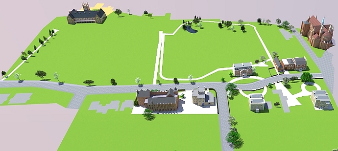
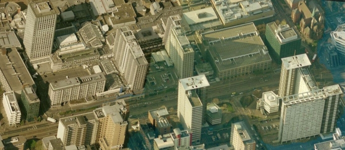 Wellesley Road 2016
Some would say that after more than a hundred years you should expect a lot of change, but that c1900 model remained more or less unchanged up to the 1960s. This can be seen in the following photograph from 1951.
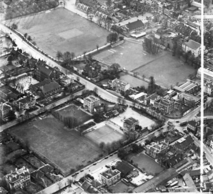
VERY LITTLE CHANGE FROM THE 1870s TO THE 1960s
After Croydon High School for Girls was built in 1874 the area in the model had a few changes. These included extensions at the rear of the High School, extensions in 1906 at the rear and side of Whitgift School, a house built in 1902 for the Whitgift School headmaster and a small print works built at the corner of Poplar Walk and Wellesley Road. These changes made very little impact on the 14 acres of playing fields and trees. There was even a small lake (28mx9m) which can be seen on the c1900 map below. The lake, which was situated directly behind he North End Empire Theatre, seems to have disappeared before the 1960s development started.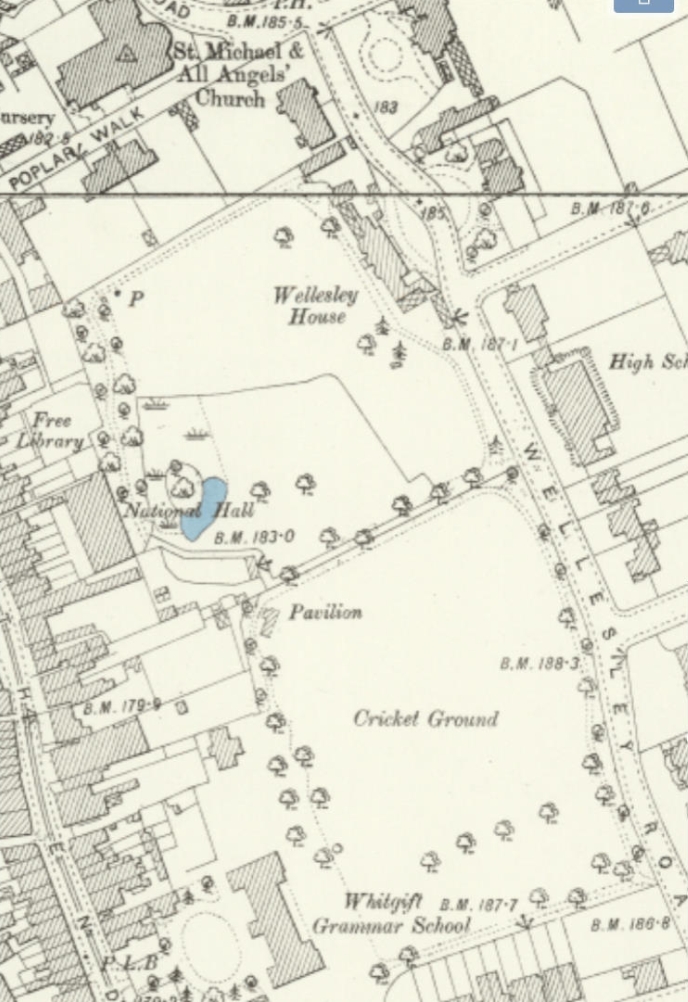
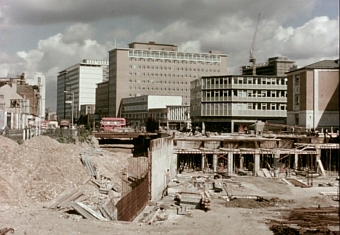
BEFORE AND AFTER THE 1960s DEMOLITIONS
The following photos were taken from the same spot. The black and white photo looks as if was taken around the mid 1950s. The other one was taken in 2004.
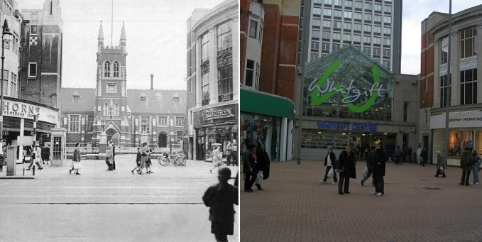 North End, High St, Croydon
The school was torn down in 1968 and the first version of the Whitgift Centre replaced it. After about 20 years the Whitgift Centre was rebuilt again. Now, in 2016, they are knocking it down and rebuilding it for the third time.
The view of the school from Wellesley Road was very attractive. The first picture shows Lime Tree Walk and the second shows the view today. The viewpoint of the second photo is a bit further back than that of the first.
The c1900 Wellesley Road view below shows Croydon High School for Girls on the right. Apart from a few changes that view would have stayed the same until the 1960s. The other picture was taken from the same point in 2016.
 Wellesley Road 2015
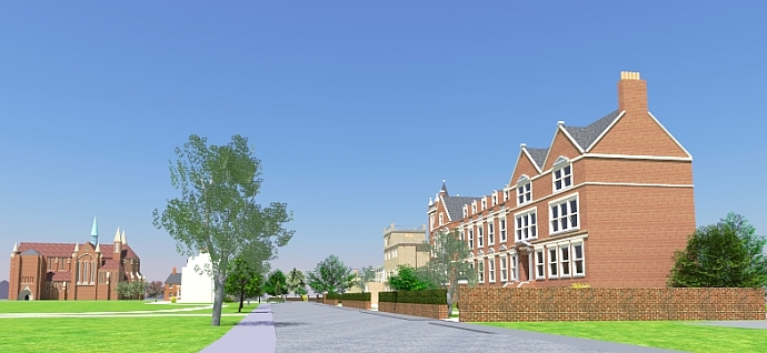
The entrance to St Michael and All Angels was built sometime after 1900. The house built in 1902 for the Whitgift School headmaster would have been the first house on the left . There was a house on Poplar Walk in front of the entrance to the church but I have left it undrawn because I have been unable to find any pictures of it. There were a couple of other buildings on Poplar Walk which would have obstructed views of some of the lower parts of the church.
The photograph below showing a group of ladies standing outside Wellesley House was taken around 1909. The roof of the Whitgift School headmaster's house can just be seen next to Wellesley House. The ladies seem to be wearing some kind of uniform. It was probably something to do with the Suffragettes. Dorinda Neligan, who had been the headmistress of Croydon High School for Girls and who lived around the corner in Sydenham Road at this time, was a prominent Suffragist.
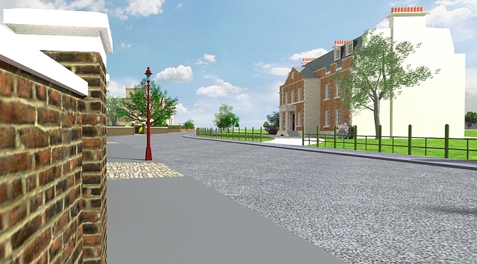
My picture is taken from a point a little further back than that of the photograph because I wanted to show more of Wellesley House. For various reason I also left a lot of trees and vegetation out of my model. One of the surprising things in the photo is how green it all looks. It just shows the importance of trees for improving the appearance of a street. The trees in the photo completely hide views of the buildings to the south of the street. Some of these buildings can be seen in my model. The gas lamp in the model is not accurate. The one I used is based on a railway station gas lamp.
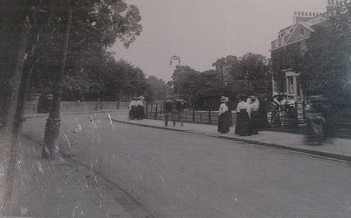
 Wellesley Road looking south 1909 (minus some of the trees)
 Wellesley Road looking south 2016
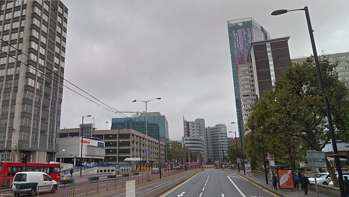
The above picture shows the 2016 view from the same viewpoint as the 1909 view. Croydon council have thoughtfully straightened the road and removed any attractive buildings which might otherwise have distracted motorists. Wellesley House was demolished in the spring of 1966.
LATEST PLANS
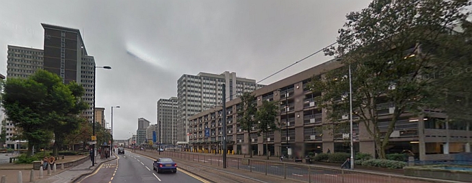
The buildings on the right in the above photo are due to be replaced by skyscrapers in the latest Croydon redevelopment plans which can be seen below.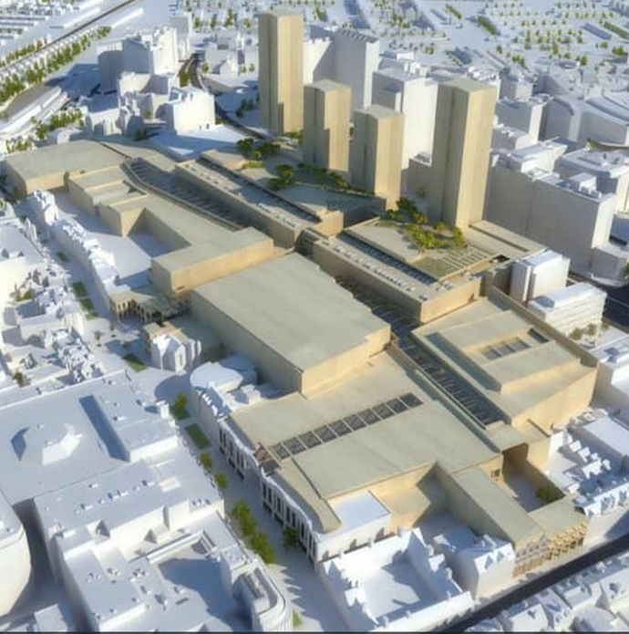 Croydon Partnership plan for the Whitgift Center
In a Youtube video discussing the latest plans Croydon's Head of Planning referred to the 1960s developments as "Croydon's 60s glory" !
This is a developer's model of the plan to develop the area around St Michael and All Angels.
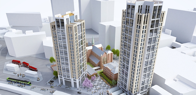 St Michael's Square plan
St Michael and All Angels, which once could be seen for miles around, will become almost invisible. In 2012 the church attracted national publicity when its parish priest and half the congregation left to join St Mary's Roman Catholic on Wellesley Road. I think there is a parallel here between the way the Church of England has foisted unwanted change on its congregationalists and the way Croydon Council have promoted development in Croydon. When I lived in the town many of the older people I talked to were dispirited about the way Croydon had changed and they were making plans to decamp to greener pastures.
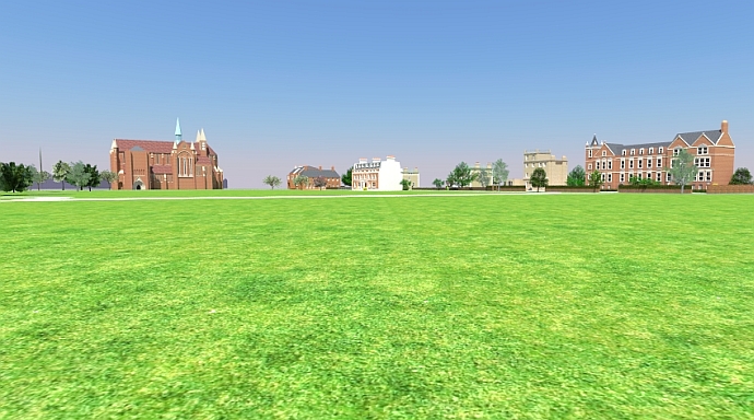
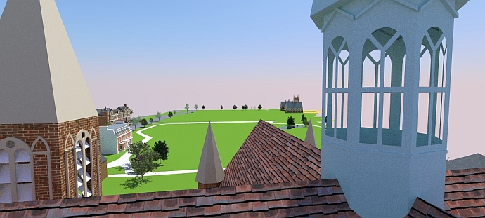 View south from the top of St Michael and All Angels 1870s to 1960s
Why and how this site was created
Until recently I had never thought much about town planning or housing development. I had noticed with sadness that gardens in my street were being paved over for cars, but there was nothing you could do about that. You can't stop house owners destroying their gardens. Some people value parking convenience over flowers and trees. Within reason people can do what they like with their private property.
It was only when my neighbour decided to convert his already large detached house into a cross between a warehouse and a chateau that I began to think about what constitutes reasonable use of private property. I didn't consider it was reasonable that my neighbour could block off much of the light to our south facing rear windows and I thought my local planning department would support me. As I sit typing this in the shadow of my neighbour's monstrosity I chuckle at my naivety. I soon realised that the function of planning departments is to support developers.
To prepare my case against the development I created some diagrams using Sketchup, the 3D modelling software. With Sketchup I was able to show exactly where the shadows would fall on my house at particular times of the year. I know you can just do this anyway with a few calculations on a bit of paper but it was nice to see an exact model of the two houses. Everyone - except my neighbour and the planning department - liked my pictures so I looked around for something else to model.
I had no need to draw new buildings and I thought it is usually pointless to draw existing buildings when you could just take a photo so I decided to draw buildings that no longer exist. Having lived in Croydon for nearly a decade I knew that would be a good place to start if I wanted to find pictures of demolished buildings. Croydon Council are probably the world champions at knocking stuff down. A lot of the rubbish they put up in the 1960s has already been replaced. I chose Wellesley Road because it is particularly ugly and I thought it would be interesting to contrast how it looked before the developers got their hands on it with how it looks now.
I began with a c1900 map of Wellesley Road showing the footprint of every building. Using the dimensions of the Whitgift Almshouse and the Church of Saint Michael and All Angels which both still exist I was able to see that the measurements of the building footprints were fairly accurate. The next step was to find photos of buildings. Using the height to width ratios in the photos together with the footprint measurements I could find the building heights. This stage surprised me. There weren't many photos on the net even though these buildings were only knocked down in the 1960s. For one or two houses I had to rely on aerial photos from the 1950s. Sometimes after drawing the house using aerial photos a better photo would turn up and I would find that I had got so much wrong that I had to start again. I've tried to be accurate but I have probably got some things wrong. Wellesley Road contained too many buildings to model everything so I have limited myself to the part of the street where the developers have done the most damage. I have been told by older people that this was the most attractive part.
This little project has given me a lot of pleasure. Sketchup is a great program. I also used the terrific Twilight Render Plugin for Sketchup. I sometimes feel that as novice user in this field I have not got the best out of these programs but life is short and we all have to cut off at some point and say "That's enough".
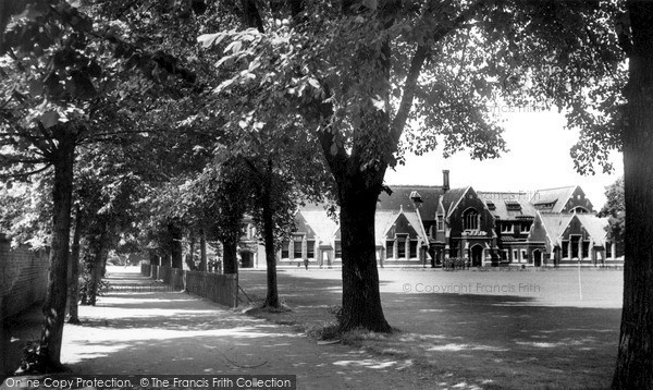
"That's the school you will be going to, my boy"
I like to think the boy in the foreground of the Whitgift School picture (below left) is holding his father's hand and being told he would be going to that school next year. Perhaps his father had gone to that school and his father's father before that. The photo looks to have been taken in the mid 1950s. It was around that time that Macmillian said "You've never had it so good". We had a stable society with full employment, little crime and no drug problem. That man and his son probably strolled off in the sunshine to Allders to enjoy a cup of tea and a cake. Everything was going well.
Our ship was steaming gently through calm waters. We didn't know that malcontents had already taken over and were plotting a new course whether we wanted it or not. It didn't matter what we thought. Some of these malcontents were straightforward saboteurs. Others were fanatics motivated by whatever half-understood fanciful theory captured their attention at any moment. The implementation of these theories led to irreparable social damage.
Utopian, or more accurately, dystopian town planners and architects destroyed our towns and cities. Visionary (short-sighted) education experts (mainly public school politicians) dismantled a grammar school system which had been this country's greatest aid to social mobility. Penal reformers (mainly politicians from criminal families) demolished a system that had kept the lid on crime for over a hundred years. Drug law reformers (usually drug taking politicians or politicians with drug taking children) made sure that the laws against drugs were not taken seriously. Free market dogmatists (politicians who thought the country had a greater need for au pairs than steel workers) turned us from a manufacturing giant into a nation of spivs, zero hour low pay workers and welfare claimants. I could go on but it is too depressing. The main point is that it didn't happen organically. It was all planned by fanatics (from the left and right) who went against the desires of the vast majority of the population.
I wish boys could still stop with their fathers and look at the old school. But the school is long gone and so have many of the fathers. Many of the children in Croydon are now brought up without fathers.
I wasn't brought up in Croydon but if I had been then I would not have gone to Whitgift School. Yet if I had walked down Croydon High Street and seen that impressive school frontage I would not have thought "That's the school for rich or clever kids". I would have thought "What a great building". That, I imagine, would have been the view of most people in Croydon. The school and its lawns and trees must have given people in the town a lot of civic pride.
Demolished Croydon
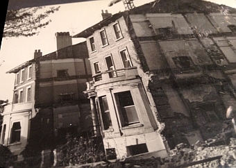 Wellesley Road east side
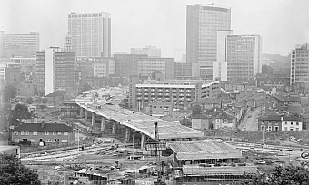 The flyover looking north towards the new center of Croydon
Hundreds of houses were demolished and communities destroyed just to speed up the anxious motorist's escape from Croydon.
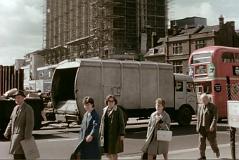 Weary Croydoners in George Street
The image above of those sad looking people wandering through the chaos with the dustbin lorry in the background is just so symbolic. Those old people were regarded by our town planners and our politicians as just the detritus of a epoch that was best forgotten. They were just an encumbrance.
 Junction of George Street and Wellesley Road 1964 looking north
 Junction of George Street and Wellesley Road 1843 (painted c1890) looking north (same viewpoint as above) by Walter William Acock (1847-1933) based on a sketch made in 1843
 Junction of George Street and Wellesley Road 1843 (painted c1890) looking west by Walter William Acock based on a sketch made in 1843.
To me it is amazing that Acock died only 30 years before that 1964 photo. His own paintings were far too bucolic for 1890 but he was trying capture how it was in 1843. I don't know what sketches he was basing his works on but it is known that there were very few houses in the street we now call Wellesley Road and which was then called New Lane. What on earth would he have made of that 1964 shambles ?
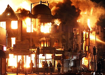
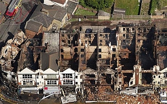
Unofficial demolition in Croydon
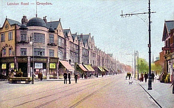 Junction of St James's Road and London Road, Croydon c1900
That dome always attracted my interest as I waited at the traffic lights opposite. It's not often that you see an interesting building in Croydon. It was sad, therefore, to discover that the building was burned down by unofficial town planners.
 Junction of St James's Road and London Road, Croydon 2011
 Junction of St James's Road and London Road, Croydon 2011
The riots were no surprise to me, or I imagine, to most people who have recently lived in Croydon. Unfortunately, when these vandals - official or unofficial - go around destroying buildings they always pick on the old and interesting ones.
People nearly died in the Croydon riots. This probably wouldn't have bothered the rioters. But people also died because of the official Croydon redevelopment. There would have been many construction accidents and probably deaths, but the pollutants from construction would have been a far great menace.
Construction pollution would have affected the health of those people living near or visiting the centre of Croydon in the decade or so of redevelopment. In addition to the illnesses and deaths caused by the dust and diesel fumes there were toxins from materials like asbestos floating around. Most of the skyscrapers were, and probably still are, full of asbestos. As the older skyscrapers are being demolished very costly efforts are being taken to remove the asbestos safely, but they weren't so careful when they were putting the stuff into the buildings. It wasn't just the joiners who were at risk as they cut up bits of asbestos it was also the members of the public walking past. On a windy day half the town centre would have been enveloped in a toxic soup of dust and pollutants.
When the skyscrapers went up they created another pollution hazard which is now known as the street canyon effect. It is quite obvious from a quick search on the net that this can concentrate and prevent the dissipation of traffic pollution. Croydon like all councils now monitors traffic pollution and, although I have no expertise in this matter, I can see that the figures for Wellesley Road are worse than for other parts of the borough. There is probably an expert somewhere who has reassured the council that these levels are nothing to worry about and they might even have a positive effect on health just like we were told that smoking was good for you, but I would think Croydonians who are careful about their health would spend as little time as possible on Wellesley Road.